

CASE STUDY:
EARTH MONITORING
NEMO-HD
Agile Microsatellite Developed by SFL Positions Slovenia as Leader in and River Basin Modeling
OVERVIEW
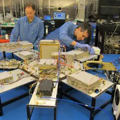
A versatile microsatellite the size of a suitcase and with a price tag a fraction of a traditional Earth observation satellite has helped establish Slovenia among the worldwide leaders in mapping and modeling river basins. SFL developed the NEMO-HD microsatellite for the Slovenian Centre for Excellence in Space Sciences and Technology (SPACE-SI) after Slovenia recognized the value of have its own national EO capabilities.
For Slovenia, the bet on microspace EO technology has paid off. Since its launch in 2020, NEMO- HD has proved its mettle by capturing 2.8-meter resolution pansharpened multispectral imagery and high-definition video for a variety of scientific and commercial applications, often partnering with the European Space Agency (ESA) on global projects. In country, the microsatellite has responded to the devastating 2022 Kras wildfire and deadly August 2023 floods.
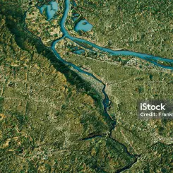
In terms of river mapping, NEMO-HD has assisted SPACE-SI and C3M – a Slovenian computer modeling company – in making a name for themselves by developing high-quality 3D ‘digital twin’ models of river basins by combining ESA Sentinel imagery with agile NEMO-HD acquisitions. Used worldwide, these 3D river models will be instrumental in balancing the often-conflicting activities of economic development and environmental sustainability.
SPACE-SI credits much of its river mapping success to the agility of the spacecraft, which enables it to acquire imagery of long river segments on a single pass in one day – even if the basin flows perpendicular to the satellite’s north-south orbital path. The onboard attitude control that makes orbital maneuverability and precise sensor pointing possible is a breakthrough small satellite technology developed with SFL of Canada.
CHALLENGE
Accurate Mapping at the Core of River Basin Modeling
In geospatial terms, a digital twin is a 3D model of a geographic area that is both visually realistic and geometrically accurate. The most important layer of the digital twin is the base map, which SPACE-SI is creating from multispectral NEMO-HD imagery. The quality of the base layer directly determines the accuracy of the monitoring and simulation applications performed with the digital twin. Capturing the base imagery in a single satellite pass significantly enhances the overall quality and consistency of the data because each image scene is acquired under nearly identical atmospheric and ground conditions.
“Imaging long stretches of north-south running rivers is relatively easy because they roughly coincide with the track of the satellite’s polar orbit,” explained Dr. Tomaž Rodič, SPACE-SI Director. “But east-west rivers are more challenging because they require the satellite to slew from side to side so the sensor can point across track.”
Despite the challenge, the achievements of SFL-developed technologies were pleasingly effective. SPACE-SI participated in a demonstration project with ESA to create digital twins of the Sava and Danube Rivers in Central Europe and Ganges River in India. These rivers each trend roughly east-west but with north-south segments as well, adding challenge to the acquisitions.
Depending on the geometry of the river, NEMO-HD can capture about 600 kilometers of cross-track imagery in one pass, explained Rodič. However, the weather was an important factor to take into account to ensure production of a high-quality base map. For the 950-kilometer Sava River, SPACE-SI planned each day’s satellite tasking to capture segments with minimal cloud cover, mapping the entire extent in five passes. The longest east-west river basin imaged in a single pass was a 290-km stretch of the Danube between Vienna and Budapest.
NEMO-HD captured same-pass high-quality imagery for similarly extensive segments of the Ganges in the GangaSat project. The success merited SPACE-SI an invitation from India to participate in aneffort to create 3D digital twins for many ecologically and economically important stretches of 22 of the most important rivers in the world.
RESULT
Satellite Attitude Control is Crucial to Agility
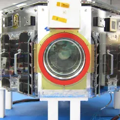
NEMO-HD’s agility in orbit allows it to rapidly slew fore and aft and side to side while capturing hundreds of overlapping images covering large geographic areas. Just as important, however, is the satellite’s stability which enables the sensor to accurately point at ground targets and acquire sharp, geometrically precise images. Attitude control is the technology that governs spacecraft pointing, stability and agility.
“Accurate, precise and agile attitude control is essential for smaller satellites to be used in demanding applications,” said SFL Director Dr. Robert E. Zee. “SFL is one of the only small satellite developers that actually delivers on its promise of outstanding pointing for the most challenging small satellite missions in the world today.”
NEMO-HD can achieve the same imaging objectives as much larger satellites, but at 10-20 times lower cost.
Through its river basin digital twin work, SPACE-SI and C3M have partnered with organizations throughout Europe, Asia, Africa, Latin America and Caribbean countries. The company expects the upcoming 22 Rivers Project – which will involve construction of a NEMO-HD receiving station global network – to highlight the utility of 3D digital twin models in sustainable monitoring and management of river basins.
SPACE-SI’s Rodič believes the program could form the foundation for a global consortium of small satellite operators monitoring the world’s rivers on a daily basis – and accomplishing a variety of other applications – with agile spacecraft similar to NEMO-HD.
Author’s Note: This case study was featured as the cover story in a 2024 issue of GeoConnexion magazine.